 Get Started midas Civil
 Featured blog of this week

Please fill out the Download Section (Click here) below the Comment Section to download the CIM Catalog.
Table of Contents
*Click the content to move to the section
2.1 IFC in general
2.2 Geographic Coordinate in CIM
2.3 Compare to Coordinate in Navisworks.
Methods for Achieving Coordinate Compatibility with AEC Collection Using IFC Files
1. Introduction
In this article, we will discuss the topic of compatibility between CIM and third-party programs, with a specific focus on the AEC (Architecture, Engineering, and Construction) Collection.
Q1. I have modeled bridges using CIM, and I want to aggregate the BIM (Building Information Modeling) models created for each discipline in road construction in Company A's INFRAWORKS. How can I achieve this?
Q2. When aggregating with INFRAWORKS from Company A using IFC files, the coordinates of the structures do not align correctly.
Answer 1. Models created in CIM cannot be directly compatible with INFRAWORKS.
This is the case with other BIM software as well. Therefore, the commonly used format for compatibility with other programs is the IFC file.
When aggregating models created in CIM within INFRAWORKS, you can use IFC files.
Additionally, it is also possible to export models created in CIM as 3D DWG files for aggregation within INFRAWORKS.
Answer 2. When aggregating using IFC files from other programs, the accuracy of the coordinates of the structures is crucial. The issues with coordinate alignment occur due to how other programs read the IFC file, specifically which item in the text field related to coordinates they choose to read.
Therefore, we will introduce a method for modifying and adjusting the IFC files generated by midas CIM to achieve coordinate compatibility with the AEC Collection.
2. Description
2.1 In General IFC
IFC (Industry Foundation Classes) is an international standard (ISO 16739) data format developed for the interoperability and compatibility of BIM models between software applications.
Within the IFC File Text Format, #5 and #37 (#Other) represent the items related to the coordinates of the structures (refer to Figure 1). The position of #5 remains fixed, while the position of #37 can vary depending on the structure. For example, #37 can be #43 or another designated number.
Since the IFC File is in Text Format, it can be opened and viewed using programs like Notepad. To modify coordinates, you simply need to change the values in the corresponding text fields.
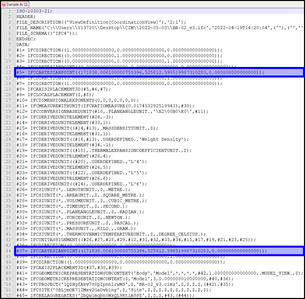
[Figure 1. IFC File Format]
In Figure 1, the #5 and #37 rows represent the IFC Cartesian Point, which corresponds to the XY values of the user-defined linear Base Point (BP).
For example, #5, #37 = IFCCARTESIANPOINT((171838, 525812, 0.00000)) indicates that the linear BP point has coordinates X=171838 and Y=525812.
2.2 Geographic Coordinate in CIM
Note: When setting the Geographic Coordinate in CIM (refer to Figure 2), the input values are specified with the Reference Coordinate as North/East.
⇒ In the IFC Text Format, it is represented as IFCCARTESIANPOINT((East, North, Altitude)).
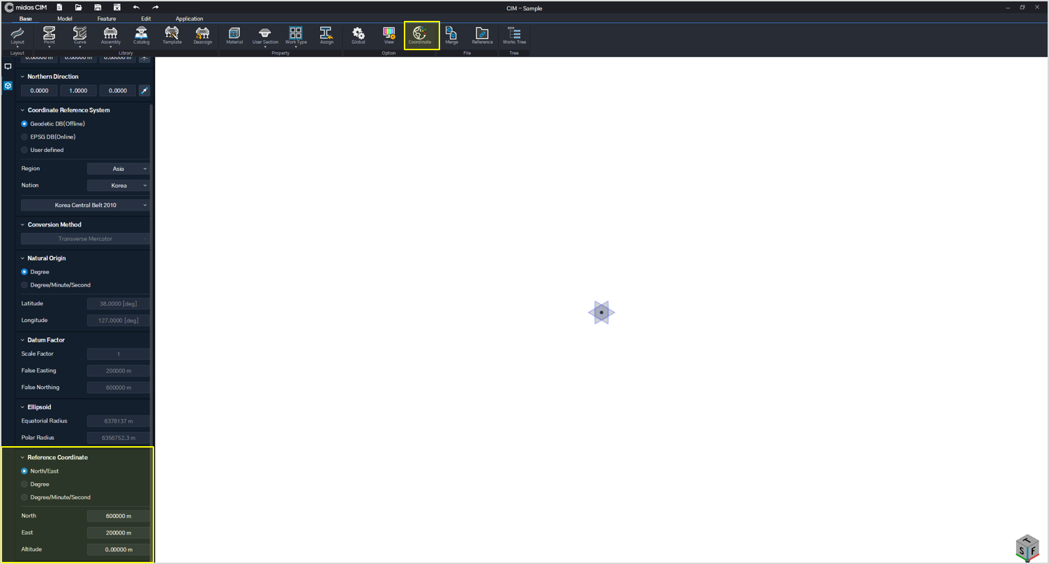
[Figure 2. Geographic Coordinate (CIM)]
2.3 Compare to Coordinate in Navisworks.
In Table 1, which is based on Navisworks, one of the tools included in the AEC Collection, the positions of rows that read the coordinates of structures within the IFC File are organized based on the version and options of the IFC file reader, whether it is the existing or latest version.
As observed in Table 1, depending on the differences in version and options, it can be noted that the positions of rows reading the coordinates within the IFC Text Format vary. This discrepancy in row positions leads to coordinate issues during compatibility.
⇒ With the exception of Navisworks (2020), in general, it is common practice to only indicate the coordinates of structures in the #5 row, regardless of the version or options of the IFC file reader. Therefore, there are no coordinate issues when it comes to compatibility.
For this reason, starting from CIM V160 Version, it is the default practice to specify the coordinates of structures only in the #5 row.
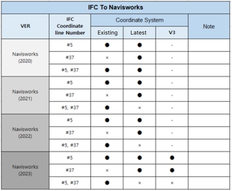
[Table 1. Compare to Coordinate in Navisworks]
※ IFC Coordinate Line Number
① #5 : When the coordinates of a structure are indicated in the #5 row.
② #37 : When the coordinates of a structure are indicated in the #37 row.
③ #5 ,#37 : When the coordinates of a structure are indicated in both the #5 and #37 rows.
⇒ You may be wondering why we tested the IFC file in Navisworks instead of INFRAWORKS. The reason is that, as shown in Figure 3, it is easier and more intuitive to visually confirm the coordinates of the IFC file within Navisworks compared to INFRAWORKS.
Of course, we also reviewed the confirmed IFC file in INFRAWORKS.
However, just like in Navisworks, if the coordinates are indicated in both the #5 and #37 (#Other) rows, errors occur. In other words, to avoid coordinate errors, coordinates should be entered in either the #5 or the #37 (#Other) row, but not both.
.jpg?width=10363&height=6033&name=figure%204.%20Compare%20to%20Coordinate%20(Example).jpg)
[Figure 3. Compare to Coordinate in Navisworks(2021)]
3. Conclusion
In conclusion, when consolidating IFC files within the AEC Collection into a single file, coordinate errors can occur if the same coordinates are entered in both the #5 and #37 (#Other) items related to the structure's coordinates in the IFC Text Format. To ensure accurate recognition of coordinates, it is crucial to enter coordinates in either the #5 or the #37 (#Other) item, but not both.
If you encounter issues with the coordinates in the IFC file, we recommend opening the file and verifying the position of the text row where the coordinates are entered. Then, modify either the #5 or the #37 (#Other) item based on the version and options of the program you are using. By following this approach, you can effectively resolve coordinate-related issues.
We hope that the information provided in this article regarding compatibility with other programs, especially concerning coordinates, will serve as a valuable reference for professionals in the field.
👉Please fill out the Download Section (Click here) below the Comment Section to download the CIM Catalog.